COURSE OVERVIEW
OE0370 : Onshore Land Surveying for Oil and Gas Upstream
OVERVIEW
| COURSE TITLE | : | OE0370 : Onshore Land Surveying for Oil and Gas Upstream |
| COURSE DATE | : | Nov 24 - Nov 28 2025 |
| DURATION | : | 5 Days |
| INSTRUCTOR | : | Capt. Mohamed Ghanem |
| VENUE | : | Abu Dhabi, UAE |
| COURSE FEE | : | $ 8000 |
| Request For Course Outline | ||
Course Description
Continuous innovation has characterized the oil and gas industry throughout its history. In recent decades, new technologies have been key to finding and extracting recoverable oil and gas resources. Offshore Survey has the most fast paced technology within the offshore petroleum industry. There are continual developments in areas such as global positioning systems (GPS), swathe and laser based bathymetry systems, acoustic positioning and in the use of autonomous underwater vehicles.
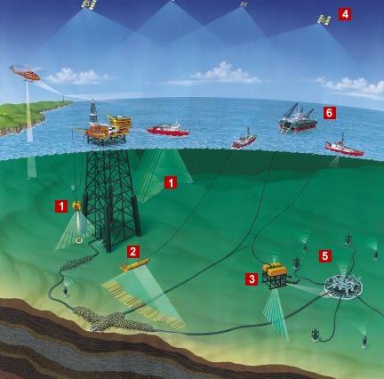
The offshore oil and gas industry relies upon survey and positioning for exploration, facilities planning, construction and maintenance. Exploration surveys include positioning and orientation of exploration drilling rigs. The planning and installation of offshore production platforms and pipelines also requires accurate survey techniques and precise positioning.
This course is designed to provide an updated overview of the Offshore Survey within oil and gas fields. The course covers this interesting technology from precise positioning to acquisition and processing of data including information on quality and movement of seawater at offshore development sites. The course covers the Hydrographic “analog” search and survey tools. These include echosounders, sidescan sonars, swathe bathymetry, autonomous underwater vehicle, pingers, boomers, and multi-electrode sparkers. The course will focus on Multibeam Echo Sounders, Airborne Laser Bathymetry, Satellite Navigation (GPS) and Differential Corrections of Satellite Navigation (DGPS). Further, the course will introduce new technologies such as Worldwide GNSS Augmentation, Electronic Charts, Underwater Positioning and Autonomous Underwater Vehicles (AUVs).
TRAINING METHODOLOGY
This interactive training course includes the following training methodologies:
LecturesPractical Workshops & Work Presentations
Hands-on Practical Exercises & Case Studies
Simulators (Hardware & Software) & Videos
In an unlikely event, the course instructor may modify the above training methodology for technical reasons.
VIRTUAL TRAINING (IF APPLICABLE)
If this course is delivered online as a Virtual Training, the following limitations will be applicable:
| Certificates | : | Only soft copy certificates will be issued |
| Training Materials | : | Only soft copy materials will be issued |
| Training Methodology | : | 80% theory, 20% practical |
| Training Program | : | 4 hours per day, from 09:30 to 13:30 |
RELATED COURSES
OE0399(KN1) : Loading Master Certification for Oil & Gas Terminals
- Date: Aug 02 - Aug 06 / 3 Days
- Location: Dubai, UAE
- Course Details Register
OE0071 : Offshore Drilling Operations
- Date: Aug 02 - Aug 06 / 3 Days
- Location: Doha, Qatar
- Course Details Register
.jpg)
OE0399(KN1) : Loading Master Certification for Oil & Gas Terminals
- Date: Aug 02 - Aug 06 / 3 Days
- Location: Dubai, UAE
- Course Details Register
.jpg)
OE0445(AR1) : Tanker & Marine Terminals: Operations, Charter Parties, Laytime, Demurrage, Loss Control, Audits, Rules & Regulations
- Date: Aug 02 - Aug 06 / 3 Days
- Location: Doha, Qatar
- Course Details Register